History of Zaporizhzhia
Foundation date of Zaporizhzhia
The date of foundation of Zaporizhzhia was considered for a long time to be 1770 - the year of the laying of the Alexandrovsk Fortress of the Dnieper defensive line of the Russian Empire. However, in 2014, the deputies of the City Council approved the year of 952 as the founding date of Zaporizhzhia - the year of the end of the treatise “On the Governance of the Empire” written by the Byzantine Emperor Constantine VII Porphyrogenitus.
However, in this treatise no settlements were mentioned related to this area, only the Kraria crossing (the Kichkas crossing on the territory of today’s Zaporizhzhia) and St. Gregory Island (Khortytsia Island). Among scientists there is no consensus on what date to consider as the date of foundation of Zaporizhzhia.
Before the Alexandrovsk Fortress
Khortytsia Island was already known in the time of Kievan Rus. Below the island along the Dnieper, after the rapids, the waterway “from the Varangians to the Greeks” continued. The narrowest place in the lower reaches of the Dnieper, where the Dnieper hydroelectric dam is located now, was actively used in different historical periods as a crossing. On Khortytsia, detachments of old Russian princes gathered for joint military operations in 1103, 1190, 1223 (the Battle on the Kalka River).
In the 15th-17th centuries, this region was the land of the Zaporizhzhia Cossacks. Their first and only fortress, located within the territory of today’s Zaporizhzhia, was Khortytsia Sich. It was built on Mala Khortytsia Island by Dmytro Vyshnevetsky (Baida), a magnate of Ruthenian origin and the first Cossack Hetman, in 1556. In 1557, the fortress was destroyed by the Crimean Tatars.
More Historical Facts…
Some historians interpret this fortification as the first Zaporozhian Sich (a proto-state of the Cossacks), however, most historians reject this interpretation, as it is not confirmed by sources. In any case, despite the short time of its existence, Khortytsia Sich played a significant role in the formation of the Ukrainian Cossacks.
In 1764, during the reign of the Russian Empress Catherine II, Novorossiya (New Russia) Governorate was formed in the territories previously controlled by the Ottomans and Cossacks, within the boundaries of which was the territory of the entire Zaporizhzhia Oblast.
With the outbreak of the Russo-Turkish War of 1768-1774, it became necessary to protect the southern borders of the governorate from the Crimean Khanate, a vassal of the Ottoman Empire. At the beginning of 1769, the army of General P. A. Rumyantsev repelled the invasion of the Crimean Tatars and reached the coast of the Sea of Azov.
Alexandrovsk Fortress
In 1770, Catherine II decided to build seven fortresses from the Dnieper rapids to the Azov Sea - the Dnieper defensive line. According to the plans, the line was supposed, on the one hand, to protect the region from the Crimean Tatar attacks, and on the other - to ensure the strengthening of Russian control over the lands of the Zaporozhian Sich.
There is no unequivocal point of view, after whom the fortress was named. The names of Field Marshal Alexander Golitsyn, Prince Alexander Vyazemsky are given; there is also an opinion that the fortress was named by Catherine II in honor of the saint, whose name was mentioned in the church calendar for the first half of 1770.
The construction of the fortress of Aleksandrovsk lasted five years. It was a powerful fortification, which had more than 100 guns. From the very beginning of the existence of the Alexandrovsk Fortress, the so-called “Vorstadt” (from German vorstadt - “suburb”) began to form near it. At first, builders-peasants, convicts, personnel serving the fortress, and retired soldiers settled there.
According to the Kuchuk-Kainarji Treaty (1774), the lands of the southern Russian steppes, called the “Wild Field”, became part of the Russian Empire. In 1775, Catherine II ordered General Peter Tekeli to end the existence of the Zaporozhian Sich, which he was able to achieve without resorting to bloodshed.
In 1783, the population of the Aleksandrovsk vorstadt was 1,230 people, 886 men and 344 women. In 1783, after the annexation of the Crimean Khanate to the Russian Empire, the Dnieper defensive line lost its military importance and was abolished. In 1785, the fortress became an urban settlement.
In 1787, by the order of Catherine II, Mennonite Protestants, subjected to religious oppression, were allowed to move to the newly conquered Russian lands along the Black Sea and in the Crimea, which were deserted after the war. In 1789, the resettlement of Mennonite Germans from the Vistula Delta (the area of ??the cities of Gdansk and Elblag) began. Mennonites in the Russian Empire were granted freedom of religion and freedom from military and civil service.
At least 23 German villages (420 families) were founded around the fortress, among them Upper Khortytsia (Chortitza) and Lower Khortytsia (Nieder Chortitza), Baburka (Burwalde), Kichkas (Einlage), Kapustyanka (Blumengart). The village of Schonwiese later became a district of the town of Aleksandrovsk.
At the same time, Russian peasants and retired soldiers began to settle here, while a lot of Zaporozhye Cossacks were resettled to Kuban, where they became Kuban Cossacks. From 1791 to 1917, Aleksandrovsk was in the Pale of Settlement for the Jews of the Russian Empire.
Alexandrovsk - a small provincial town
At the end of the 18th century, Aleksandrovsk became a transport center - it was through it that goods for the construction of Kherson and the Black Sea Fleet went. With the growth of the trade role of Odesa and the change in the direction of the main trade routes in the region, Aleksandrovsk began to decline; this was facilitated by the abolition of the Dnieper defensive line in 1797.
In 1804, the population of Alexandrovsk was about 2.5 thousand people. In 1806, it became a county town of the Yekaterinoslav Governorate with a town council, a post office, courts, and a treasury. In 1811, Alexandrovsk received its coat of arms (the current coat of arms of Zaporizhzhia is almost an exact copy of it). In the middle of the 19th century, Aleksandrovsk was an ordinary provincial town. In 1861, about 3.8 thousand people lived in the town.
The presence of a pier on the Dnieper below the rapids, as well as the construction of a railway from the center of the Russian Empire to the Crimea, contributed to the growth of Aleksandrovsk. In 1873, a section of the Catherine Railway from Lozovaya to Aleksandrovsk was opened, the first railway station was built, called the Southern Station.
In 1875, the construction of the railway to Sevastopol was completed. Various goods (bread, coal, cattle, timber, etc.) were transported to Alexandrovsk by rail, where they were loaded onto barges and rafted down the Dnieper to sea ports, mainly to Odesa.
As a result, the town gradually began to turn into an important transport hub of the region, its industry began to develop too. In the 1870s, there were 5 agricultural machinery plants in Alexandrovsk. In 1897, the population of the town was 18,849 people, of them Ukrainians - 8,101, Jews - 5,248, Russians - 4,667.
The construction of the second Catherine Railway, which passed through Alexandrovsk and connected the Krivoi Rog Iron Ore and Donets Coal Basins in 1902, and the significant expansion of the harbor, gave a powerful new impetus to the development of the town and its economy. The second railway station was built.
In 1913, on the eve of the First World War, the town’s population reached 63,600 people. During the First World War, a number of enterprises were evacuated from the western regions of the Russian Empire to Alexandrovsk. During the Civil War in the former Russian Empire, power in the town changed several times.
Zaporizhzhia before and during the Second World War
In 1921, Aleksandrovsk was renamed to Zaporozhye (literally meaning “below the river rapids”) by decision of the All-Ukrainian Central Executive Committee. Zaporizhzhia is the Ukrainian spelling of this name.
The natural conditions around the city were favorable for the construction of a giant hydroelectric power station. This fact, together with the availability of transport routes and the geographical position between Krivoy Rog ore and Donetsk coal, coincided with the intention of the Soviet authorities to industrialize the country. It was planned to build a powerful industrial site nearby, primarily metallurgical plants.
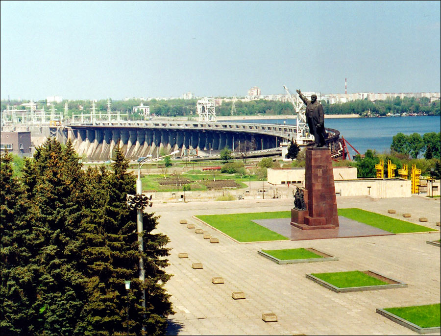
The turning point in the history of the town was the construction of the Dnieper Hydroelectric Power Station (DneproGES), which was opened on October 10, 1932. The Dnieper rapids were flooded and direct navigation along the Dnieper River became possible. The construction of a large industrial complex of ferrous and non-ferrous metallurgy began. DneproGES became one of the main symbols of Soviet industrialization.
In the middle of 1928, Professor I. G. Aleksandrov drew attention to the need for a plan for the development of the city around the Dnieper Hydroelectric Power Station under construction. In September of the same year, the Council of People’s Commissars of the Ukrainian SSR announced a competition for drawing up a layout plan for the Big Zaporizhzhia. On April 29, 1932, the city project was approved. New Zaporizhzhia was designed as if apart from the old Aleksandrovsk. The architectural qualities of the project were so significant that its model was presented at the 1939 World’s Fair in New York as an outstanding example of socialist urban planning.
Between the dam and the industrial site, where the plants were being built, about 10 km from the center of old Aleksandrovsk, a settlement #6 named Sotsgorod (Socialist city) was founded. Sotsgorod was created with the idea of building a city of the future, a city-garden. The ideas of Soviet urban avant-garde were used in the design of buildings. In 1937, Zaporizhzhia produced about 60% of Soviet aluminum, 60% of ferroalloys, 100% of magnesium, and 20% of rolled steel. In 1939, the city became the center of the newly formed Zaporizhzhia Oblast. Its population was about 289 thousand people.
On August 18, 1941, during the Second World War, the Germans broke through the defenses of the Soviet troops west of Zaporizhzhia. In order to delay the offensive of the German troops, the Soviet command decided to blow up the bridges connecting the island of Khortytsia with the right and left (Zaporizhzhia) banks of the Dnieper and the Dnieper hydroelectric dam.
As a result of the explosion, a hole more than 100 meters long appeared in the dam, through which a 30-meter wave gushed down, causing destruction and death of people who found themselves in the riverside zone (German troops, the Red Army soldiers, who carried out the crossing across the Dnieper, as well as civilians). The number of victims among the Red Army and the civilian population is not known, since no calculations were made immediately, most likely thousands of people. The German command estimated its losses at 1,500 people.
Using the surviving bridge, the Germans entered Khortytsia, occupied it and began shelling the city. On the night of September 3-4, 1941, the troops of the Red Army and the militia crossed the Dnieper and landed on Khortytsia in order to drive the Germans off it. After the liberation of the island, the shelling of the city significantly weakened. In a short time, 22 factories of all-Union significance, 26 enterprises of the light and food industries were evacuated, institutes, educational institutions, a theater, and a museum were evacuated too. The defense of Zaporizhzhia lasted a month and a half - until October 4, 1941.
By the summer of 1942, the Germans rebuilt the DneproGES and partially restored the Zaporizhzhia steel mill. During the occupation, the Germans conducted a census of the population. According to it, on May 1, 1942, 103,375 people lived in Zaporizhzhia. October 12-14, 1943, the city was liberated by the Red Army. Soviet intelligence officers and sappers managed to save the Dnieper hydroelectric power station from destruction.
Zaporizhzhia after the Second World War
In the postwar years, Zaporizhzhia was actively rebuilt. DneproGES was restored by 1947. By the end of 1950, about 90% of residential buildings were restored. Two two-tiered bridges across the Dnieper, opened in 1953, became cultural and engineering attractions of the city. The famous Soviet movie “Spring on Zarechnaya Street” was filmed in Zaporizhzhia (director M. Khutsiev, 1956). In this movie you can see what the city was like in post-war times. In 1956, the population of Zaporizhzhia was about 381 thousand people.
The growth of the old part of the city and the new one (Sotsgorod) led to their unification in the 1960s. At that time, large new residential districts were founded. In 1960, the plant “Kommunar”, changed its direction of activity and instead of harvesters began to produce famous Soviet mini-cars ZAZ Zaporozhets. In 1970, about 658 thousand people lived in the city.
In the 1950s-1980s, Zaporizhzhia continued to develop as a large industrial city. During this period, the machine-building, industrial and metallurgical institutes, technical schools of the city developed rapidly too. In the late 1980s, the population of Zaporizhzhia reached 900 thousand people.
After the collapse of the Soviet Union, in independent Ukraine, the population of Zaporizhzhia began to decline. From 1992 to 2022, the city’s population decreased by about 20%.
Pictures of Zaporizhzhia
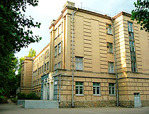
Zaporizhzhia architecture
Author: Mikhail Pogorely
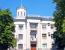
Summer in Zaporizhzhia
Author: Altukhov Andrey
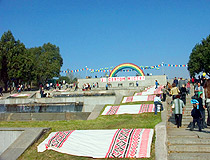
Cascade fountain Rainbow in Zaporizhzhia
Author: Max Stolbinsky
Zaporizhzhia - Features
The name “Zaporizhzhia” literally means “a city beyond the river rapids”. The name recalls that before the construction of the DneproGES dam in 1932, in this place where the Dnieper River crosses the rocky southern border of the Ukrainian Shield, numerous river rapids ended. The City Day of Zaporizhzhia is celebrated on the first Saturday of October.
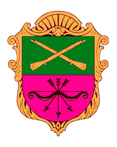
The first official coat of arms of Zaporizhzhia, at that time the town of the Russian Empire known as Alexandrovsk, was approved in 1811. The coat of arms was described as follows: “Two crossed yellow guns are placed in a green field. In a crimson field, a black bow with three arrows facing downwards, which signifies the strength of our weapons and the weakness of the Tatar force” (Alexandrovsk was founded as a fortress to protect this region from the Crimean Tatars of the Crimean Khanate). Today’s coat of arms of Zaporizhzhia as in general repeats its historical coat of arms.
Zaporizhzhia stands on both banks of the Dnieper, between which the island of Khortytsia is located. The city is located in the continental climate zone, characterized by warm summers with low rainfall. The warmest month is July with an average temperature of plus 23.8 degrees Celsius. The winter is moderately mild, and there is often a lack of permanent snow cover. The coldest month is January with an average temperature of minus 2.7 degrees Celsius.
This city is one of the largest industrial centers of Ukraine. Machine-building, energy and metallurgical complexes of national importance are concentrated in it. In total, its industrial potential includes more than 290 enterprises.
The metallurgical complex is represented by enterprises of ferrous and non-ferrous metallurgy: PJSC “Zaporizhzhia Iron and Steel Works ” Zaporizhstal”, PJSC “Zaporizhzhia Ferroalloy Plant”, PJSC “Electrometallurgical Plant “Dneprospetsstal”, LLC “Titanium-Magnesium Plant” (the only producer of spongy titanium in Ukraine, which also produces titanium ingots).
It is also worth mentioning such machine-building enterprises as PJSC “ZAZ” - the only enterprise in Ukraine that has a full cycle of production of cars, also producing trucks and buses; JSC “Motor Sich” - a manufacturer of engines for aviation equipment, industrial gas turbine units; PJSC “Zaporizhtransformator” - one of the world leaders in the production of transformers; PJSC “Zaporizhzhia Heavy Crane Building Plant” - one of the largest crane-building enterprises in Ukraine.
The ecological situation in Zaporizhzhia and the region is not favorable because of a large number of industrial enterprises and outdated cleaning technologies. A significant part of industrial enterprises is located in the center of residential districts.
The left and right banks of the city are interconnected by the DneproGES dam, Preobrazhensky bridges, and an arch bridge. Today, the main transport problem in Zaporizhzhia is the low capacity of its bridges and the dam. In 2004, the construction of new bridges began (parallel to Preobrazhensky bridges), but it has not yet been fully completed. In 2022, the upper parts of the bridges were put into operation.
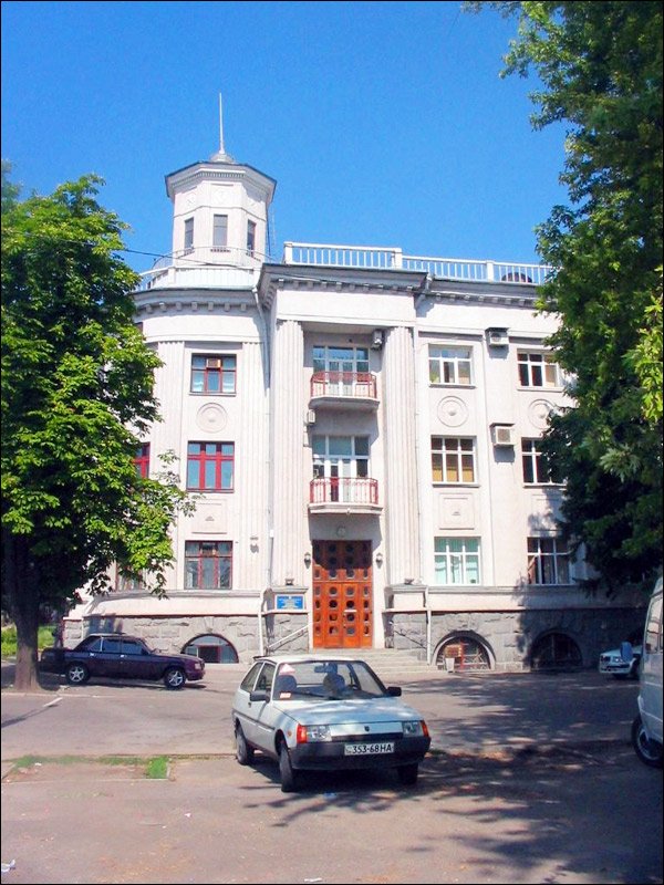
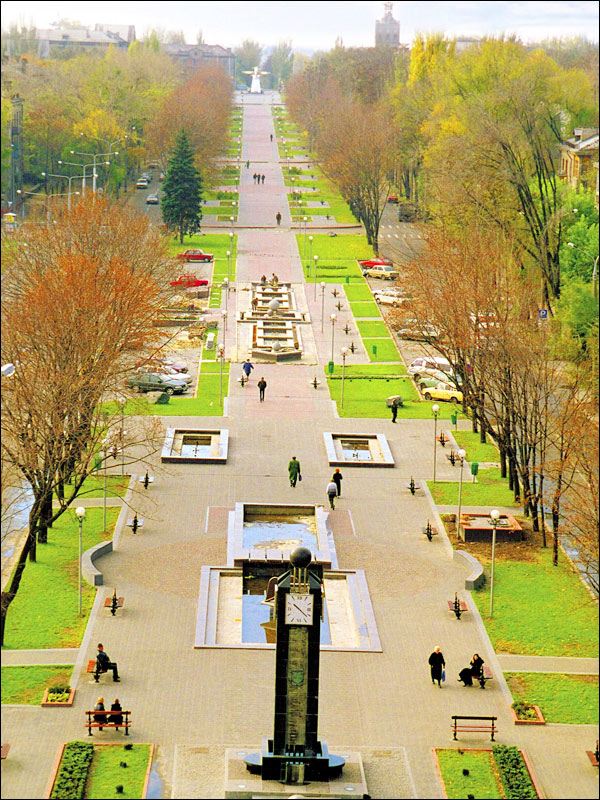
The main street of Zaporizhzhia is Sobornyi Avenue, which crosses almost the entire left-bank part of the city from the railway station to the Dnieper Hydroelectric Station. Its length is about 11 km. On this street monumental buildings constructed in the Stalin Empire style coexist with architectural monuments of constructivism of the 1930s. In the Oleksandrivskyi district - the oldest part of the city - the buildings of the late 19th - early 20th centuries have been preserved.
The city of Zaporizhzhia has a significant tourist potential because of its favorable geographical location, rich history, national and cultural diversity, architecture, natural sites, unique combination of urbanized and industrialized areas with protected areas within the city limits.
Main Attractions of Zaporizhzhia
National Reserve Khortytsia - one of the Seven Wonders of Ukraine and the main tourist destination associated with Zaporizhzhia. It is the largest river island in Europe stretching for 12 km along the banks of the Dnieper River. The nature of this island is unique. Almost all landscapes of Ukraine can be found on its territory.
Khortytsia is a favorite recreation place for locals and visitors of Zaporizhzhia with sanatoriums, beaches, and water excursions. The reserve has several tourist routes devoted to the history of Zaporizhzhia and its unique nature.
In the north of the island there is the Historical and Cultural Complex “Zaporozhian Sich”. This is a generalized image of a Cossack village with a palisade, a church, a house of the ataman, a school, a smithy, a tavern, etc. Nearby you can find the Museum of the History of the Cossacks with an observation deck, which offers an impressive view of the Dnieper Hydropower Station.
In the central part of Khortytsia you can find the Historical and Cultural Complex “Scythian camp”. In the beginning of the 20th century, 129 ancient burial mounds were found on the island. The oldest of them were erected in the Bronze Age, about 4-5 thousand years ago. There are a lot of interesting stone artifacts in this open-air museum.
In the south-eastern part of Khortytsia there is the Folk-Ethnographic Equestrian Theater “Zaporozhye Cossacks”. By order of large tourist groups, horse and folklore performances are held here. After the performances, you can ride horses, as well as buy handmade souvenirs.
Dnieper Hydroelectric Station (DneproGES) (1927-1932) - the second most famous tourist symbol of Zaporizhzhia and the largest hydroelectric power plant in Ukraine. In 1932-1956, it was the largest hydroelectric power station in the USSR and Europe. The installed capacity of the station is 1578.6 MW. The dam of the station stretches for 760 meters across the Dnieper River and connects its right and left banks. At night, the dam is illuminated. It is an industrial object, but at the same time a magnificent architectural monument.
Museum of Retro Cars “Faeton” - the largest Ukrainian private museum of technology (retro cars, motorcycles and military equipment) located in the industrial zone of Zaporizhzhia. The museum has 7 exhibition halls with hundreds of exhibits - serial and rarer prototypes of cars and motorcycles, weapons, military and service equipment from different times and peoples. A lot of them are used in various exhibitions, historical reconstructions and movies. Vyborz’ka Street, 8. Opening hours: 09:00-17:00.
Zaporizhzhia Regional Museum. The museum is located in one of the few preserved buildings of the pre-revolutionary Alexandrovsk. The main exposition presents the history of this region from ancient times to the present and shows its nature, the life of the Zaporizhzhya Cossacks. Its archaeological, ethnographic, numismatic, paleontological collections, herbariums, and old printed books are of great historical and cultural value, as well as archaeological finds from the Zaporizhzhya mound, Sarmatian jewelry, collections of insects, stuffed rare birds, weapons and household items of the Zaporizhzhya Cossacks. Troitska Street, 29/16.
Museum of Engineering of Bohuslaev (Museum of Technology “Motor Sich”). On the first floor of this museum there is an exposition dedicated to the history of the Zaporozhye Engine Building Plant with a unique collection of piston and jet aircraft engines. On the second floor there is a collection of motorcycles of foreign and Soviet production. Also there are collections of samovars and hunting weapons. On the territory of the museum you can see an exhibition of military equipment. Kopenkina Street, 27?.
Zaporizhzhia Children’s Railway (1972) - one of the best and the longest children’s railways in Ukraine. The length of the main track of the railway is 8.6 km, the total length - 9.4 km. There is a railway station and 7 platforms for passengers. Also the railway passes through a tunnel 80 meters long. This is one of the few children’s railways operating all year round. Pryvokzalna Street, 1.
Voznesenivs’kyy Park. This park of 4.5 hectares with elements of modern landscape design is located next to the cascade of fountains “Rainbow” (Mayakovs’koho Avenue, 26) on the embankment of the Dnieper River. Here you can find an artificial pond with fountains, a lot of installations and insta places. This is one of the cleanest and well-organized parks in Zaporizhzhia, a place for recreation and various cultural events. Pryberezhna Highway.


The comments of our visitors
All 5 comments