History of Khmelnytskyi
Khmelnytskyi (Ploskirow) in the 15th-17th centuries
People lived on the territory of today’s Khmelnytskyi from ancient times. A lot of archaeological sites have been discovered in the vicinity of the city. Khmelnytskyi originates from a small settlement of Ploskirow or Ploskirowce, the time of foundation of which is unknown. The first written mention of it dates back to 1431.
In 1547, the Polish king Sigismund II Augustus gave Ploskirow into the possession of Maciej Wlodek, a Polish nobleman and magnate, who paid great attention to strengthening existing and building new fortifications in the lands subject to him. Ploskirow was identified as an important strategic point.
The favorable geographical location of Ploskirow was of great significance for its further development and the construction of fortifications in it required for the survival of the population during the regular attacks of the nomadic Crimean Tatars. In the 1560s-1580s, the presence of the castle contributed to the transformation of Ploskirow into an urban settlement. In 1566, it was granted Magdeburg rights (town privileges, which regulated the degree of internal autonomy).
In 1648-1654, during the Khmelnytsky Uprising (the Cossack-Polish War), Ploskirow and its environs found themselves in the center of conflict between the Cossack and Polish troops. The town repeatedly passed from hand to hand, while suffering great destruction from both the Polish troops and the Cossack and insurgent detachments, and was eventually devastated. In 1672, Ploskirow, like all of Podolia, was occupied by the Ottoman Empire. In 1699, the Ottomans left Podolia and Ploskirow again came under the control of Poland.
More historical facts…
Khmelnytskyi (Proskurov) in the 18th - early 20th centuries
By the end of the 18th century, the population of Ploskirow was about 2,500 people. In 1795, after the Third Partition of Poland, this region was annexed to the Russian Empire and became part of the Podolia Governorate. After that, the name of the town changed to Proskurov.
In 1806, there were 487 houses in Proskurov, of which only one was made of stone, others were adobe and wooden. The town also had 68 wooden and 7 stone shops, 2 mills, a Greek-Russian church, a Catholic chapel, and two Jewish schools. The population of Proskurov was 2,022 people. In 1822, a devastating fire broke out in the town, most of its wooden buildings burned down.
In 1870, a railway station was built on the eastern outskirts of the town. The railway contributed to the intensive development of Proskurov. At the turn of the 19th and 20th centuries, several industrial enterprises were opened (tobacco, sugar, and brick factories, iron foundry, brewery). In 1897, the population of Proskurov was 22,855 (Jews - 11,369, Ukrainians - 4,425, Russians - 3,483, Poles - 2,824).
By 1909, its population increased to about 36,000 people. At the beginning of the 20th century, Proskurov became the largest trading center in the Podolia Governorate. It played a particularly important role in the export of grain. The second factor that contributed to the rapid development of the city was the quartering of military units in its area, which was due to its favorable strategic location near the state border of the Russian Empire. In the summer of 1914, with the outbreak of World War I, Proskurov became a frontline city.
In 1917-1920, during the struggle of Ukrainians for the creation of their independent state, Proskurov played the role of an important stronghold of the Ukrainian People’s Republic. On November 18, 1920, Soviet power was established in the city. In December 1922, as part of the Ukrainian SSR within the Soviet Union, it became the center of the Proskurov district of the Podolia Governorate.
Khmelnytskyi (Khmelnitsky) in Soviet Ukraine and independent Ukraine
In the 1930s, during the industrialization of the USSR, Proskurov became an industrial center. In the spring of 1941, it received the status of the administrative center of Kamenets-Podolskiy Oblast.
On July 8, 1941, during World War II, the city was occupied by German troops. During the years of occupation, about 9,500 Jews, almost 60% of the city’s Jewish population, were exterminated. Tens of thousands of prisoners of war and civilians were also killed in concentration camps located near Proskurov. On March 5, 1944, it was liberated by the Red Army.
On January 16, 1954, the Decree of the Supreme Soviet of the Ukrainian SSR was issued: “To commemorate the historic event - the 300th anniversary of the reunification of Ukraine with Russia and celebrating the services to the Ukrainian and Russian peoples of the outstanding statesman and commander Bogdan Khmelnitsky, rename the city of Proskurov to the city of Khmelnitsky, and Kamenets-Podolskiy Oblast to Khmelnitsky Oblast.
Several plants of all-Union significance were built. In particular, the plant of transformer substations became the leading one in the USSR for the production of transformers for railway transport, the plant “Kation” was one of the largest Soviet manufacturers of capacitors, the state enterprise “Novator” was the only manufacturer of aviation special equipment for military purposes in the USSR. These enterprises turned Khmelnitsky into a major industrial center.
From 1959 to 1979, the city’s population almost tripled, from 62,000 to 172,000. Khmelnitsky also became an important military-strategic center. Combat positions of intercontinental ballistic missiles were deployed near Khmelnitsky. A significant event that complements the military page of the history of the city was the founding of the Khmelnytsky Higher Artillery Command School in 1970. In the 1990s, on its basis, the National Academy of the State Border Guard Service of Ukraine named after Bohdan Khmelnytsky was established.
In 1989, the population of Khmelnitsky was about 237,000 people. After the collapse of the USSR and Ukraine’s independence, all intercontinental ballistic missiles with nuclear warheads were withdrawn from the territory of the country, in particular from Khmelnitsky Oblast.
In the 1990s, Khmelnytskyi became one of the largest shopping centers in Eastern Europe. Today, a whole market complex operates here, which covers an area of more than 18 hectares and includes 24 separate clothing markets.
Architecture of Khmelnytskyi
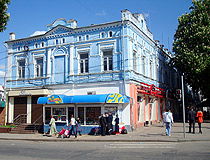
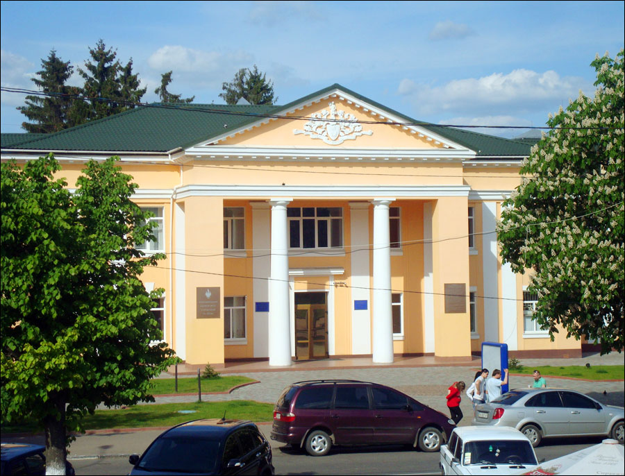
Old house in Khmelnytskyi
Author: Valery Podlesny
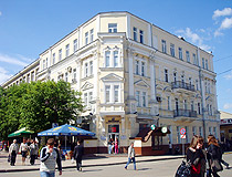
Summer in Khmelnytskyi
Author: Valery Podlesny
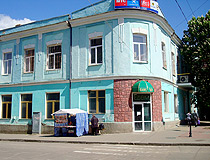
Cafe in Khmelnytskyi
Author: Valery Podlesny
Khmelnytskyi - Features
The coat of arms of today’s Khmelnytskyi, which depicts three crossed golden arrows, is similar to its original coat of arms from the time of the Polish-Lithuanian Commonwealth. Evidence of this emblem was found in the records of the Friesian traveler Ulrich von Werdum, who was in Podolia in 1671. These records tell that one of the members of the Zamoyski noble family, who owned Khmelnytskyi (then Ploskirow), died from mortal wounds when he was pierced through with three spears in one of the battles.
Before his death, he told the Polish king that “mortal wounds torment me less than one of my neighbors, who owns half of my village.” Therefore, later the king bought this half of the village, which he presented to Zamoyski along with the coat of arms with three crossed spears. Later they were probably replaced with arrows.
Khmelnytskyi is located about 360 km south-west of Kyiv by roads. The highway Zhytomyr - Chernivtsi (N03) and part of the international route E50 (Stryi - Ternopil - Vinnitsa - Kropivnitskiy - Znamenka (M12)) pass through the city. Public transport is represented by trolleybuses and buses. The airport in Khmelnytskyi has not been functioning since 2014. The nearest international airports are located in Lviv and Kyiv. The easiest way to get to Khmelnytskyi from these cities is by rail.
The climate in this city is temperate continental with warm summers and mild winters. The average temperature in January is minus 5.3 degrees Celsius, in July - plus 18.5 degrees Celsius.
Khmelnytskyi is an important industrial center of Ukraine. The chemical and petrochemical industries, the machine-building industry, the food industry, and the construction industry occupy the largest share in the structure of the city’s industrial production. Mechanical engineering enterprises produce machine tools, forging and pressing equipment, transformers, wood-cutting tools, plows, agricultural machines, cables, and electrical products.
The city of Khmelnytskyi is also known throughout Ukraine as a trading center. The Khmelnytskyi clothing market is one of the largest markets in Europe. People come here not only from all over Ukraine, but also from Poland, Belarus, Moldova, and other neighboring countries.
This is also an important cultural center. There are several theaters, a regional philharmonic society, movie theaters, several museums, and other cultural institutions. The City Day of Khmelnytskyi is celebrated on the last weekend of September.
Main Attractions of Khmelnytskyi
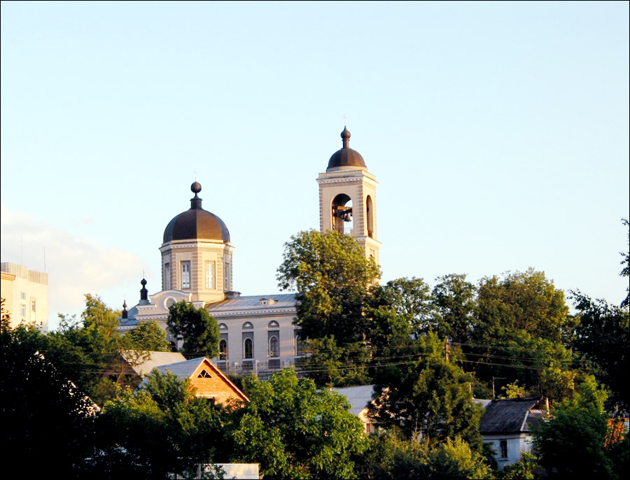
Cathedral of the Nativity of the Blessed Virgin Mary (1835-1837) - the oldest building in Khmelnytskyi constructed in the style of classicism. This quiet and cozy church located near the Khmelnytskyi market, is one of the symbols of this city. It was built on the site where the Proskurov Orthodox Church, founded back in the 17th century, once stood. During the fire of 1822, it completely burned down. Vaiser Street, 15.
Khmelnytskyi Regional Museum of Local Lore - one of the most interesting museums in Khmelnytskyi Oblast with a large collection of exhibits on the history and culture of Podilia. The exposition is presented in six halls. In total, there are over 62 thousand exhibits, among which 6.5 thousand belong to the archaeological collection and more than 9 thousand - to the numismatic collection.
Museum visitors can see a wonderful collection of porcelain from the late 19th - early 20th centuries, furniture and fabrics, as well as icons, old weapons, and household items. The museum also has archival materials on the history of not only Podilia, but also Ukraine in general. The museum library has more than 20 thousand publications, including about 3 thousand unique books of the 19th century. Podil’s’ka Street, 12.
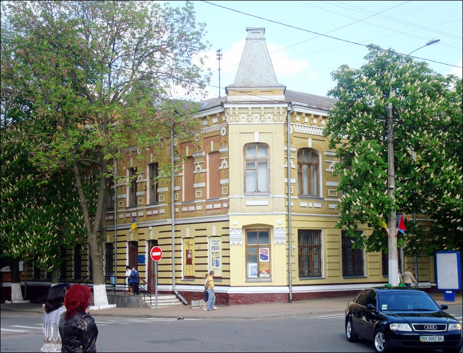
Khmelnytskyi Regional Art Museum. This museum is housed in a former bank building constructed in 1903. Few such houses have survived in Khmelnytskyi, so this building itself is an important city sight. In total, about 8 thousand works of art created by dozens of contemporary Ukrainian artists are exhibited here. Proskurivs’ka Street, 47.
Khmelnytskyi Studio Museum of Photographic Art. This museum, opened in 2010, is housed in a building that is an architectural monument constructed in the Art Nouveau style in the early 20th century. This is the first and only museum of photographic art in Ukraine. Its collection of several thousand items (cameras, lenses, magnifiers, exposure meters, and other accessories) illustrates the development of photography and camera production from the late 19th to the late 20th century.
In the lobby there is a permanent exhibition “Proskurov photographers of the late 19th - early 20th centuries” and “Old-New City”. The photographs depict the sights of Khmelnytskyi, houses, streets, and cityscapes. Proskurivs’ka Street, 56.
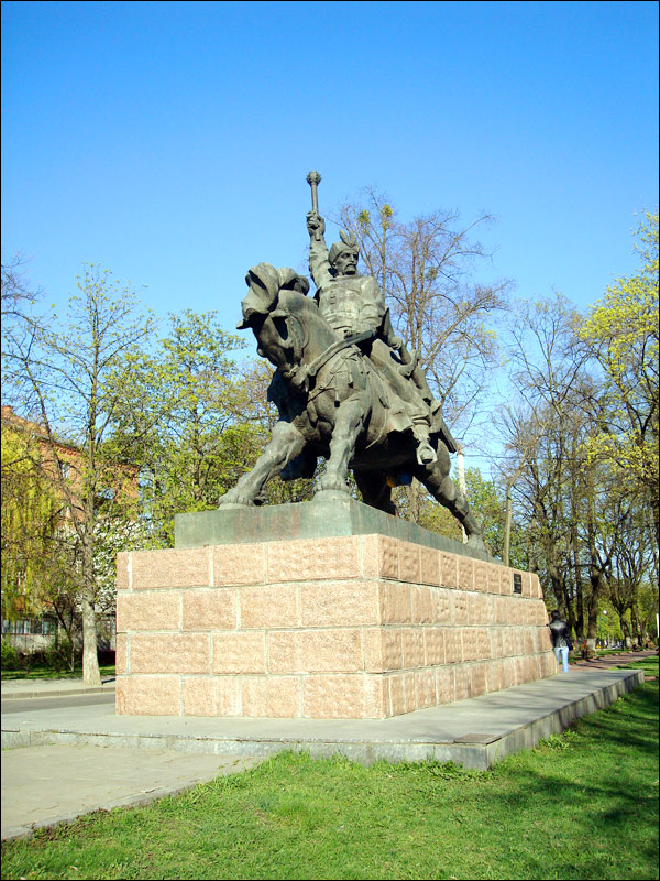
Monument to Bohdan Khmelnytsky. This equestrian monument was installed in front of the Khmelnytskyi philharmonic society, next to the building of the Khmelnytskyi regional state administration, in 1993. Bohdan Khmelnytsky (1595-1657) was a famous Ukrainian commander and statesman, hetman of the Zaporizhzhya Host, the organizer of the uprising of the Zaporizhzhya Cossacks against the Polish rule, as a result of which Left-Bank Ukraine and Kyiv left the Polish-Lithuanian Commonwealth.
The monument turned out to be very expressive and pompous, but it sparked controversy among locals due to the unnatural posture of the horse and the general disproportion of the figures. Proskurivs’ka Street, 107.
Taras Shevchenko Public Garden - a park-monument of landscape art of local importance located in the center of Khmelnytskyi and covering an area of about 5 hectares. Here you can see the monument to Taras Shevchenko, a famous Ukrainian poet, public, and political figure, as well as interesting metal sculptures cast by N. Mazur. This park, thanks to cool shady alleys and colorful flower beds, is a favorite place for walking not only for locals, but also for tourists. Proskurivs’ka Street, 40.
Park of Culture and Rest named after Mykhaylo Chekman - a park-monument of landscape art of local importance located on the right bank of the Buh reservoir. The area of the park is 140 hectares. More than 30 species of trees and shrubs grow on its territory. At the entrance there is an alley of sculptures, on the territory of the park you can find a summer theater, a music stage, a dance floor, pavilions, rides, sports and playgrounds, a mini zoo, recreation areas. Parkova Street, 1.
Synagogue of Artisans (1890) - the only surviving Jewish temple in Khmelnytskyi. This small building was erected in the Jewish quarter of artisans-bakers located opposite the today’s central food market. In Soviet times, it housed a children’s and youth sports school of gymnastics. In the early 1990s, the synagogue was returned to the local Jewish community. The reconstructed synagogue was opened in September 2009. It houses a permanent photo exhibition of Jewish monuments and tombstones, as well as an exposition of Jewish religious items. Pekars’kyi Lane, 2.
Monument to Baron Munchausen - the first monument to Baron Munchausen on the territory of the former USSR. This monument, erected in 1970, is dedicated to Hieronymus Karl Friedrich von Munchausen, a historical figure and literary character whose name has become a household name as a designation for a person who tells incredible stories. It is located in the central part of Khmelnytskyi, in the courtyard of a residential building at Kam’yanets’ka Street, 48.
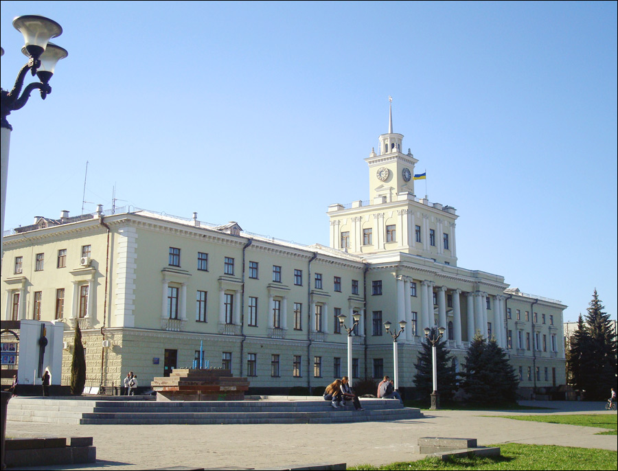
Other worth seeing architectural monuments of Khmelnytskyi are St. George Church (1898) (Tolstoho Street), Khmelnytskyi City Council (1904) (Gagarina Street, 3), Department of State Registration of Civil Status Acts (1903) (Gagarina Street, 4), Planet Cinema, known to locals as “the fire tower” (1954) (Podil’s’ka Street, 31).


The comments of our visitors