11
Amazing Scenery in the Area of the Flooded Village of Bakota
No comments · Posted by Alex Smirnov in Nature, Travel, Video
Bakota, located about 50 kilometers from Kamianets-Podilskyi in the territory of the Podilski Tovtry National Park, in the very south of Khmelnytskyi Oblast, was once a village, but its story ended in 1981, when it was flooded due to the construction of the Dniester hydroelectric complex.
Today, Bakota is a place with amazing nature and beautiful views. Here, from the rocky high bank of the river, you can spend hours watching the water surface and picturesque cliffs. There are also boat excursions available. On the territory of Bakota, you can spend the night in a tent, fish.
Tags: Kamenets Podolskiy city · Khmelnitsky oblast
24
The Medzhybizh Fortress – the view from above
No comments · Posted by Alex Smirnov in Travel, Video
Medzhybizh Fortress is a monument of fortification architecture of the 16th century built in the Renaissance style and located about 40 km east of Khmelnytskyi. This fortress is listed in the State Register of National Cultural Heritage of Ukraine.
The fortress has the shape of an elongated triangle with powerful walls and corner towers that protrude significantly beyond the line of walls. The courtyard has a length of 130 m, the largest width (on the western side) is 85 m. The wall thickness is up to 4 m, the height is up to 17 m.
Tags: fortress · Khmelnitsky oblast
17
Church of the Assumption of the Virgin in Skala-Podilska
No comments · Posted by Sergei Rzhevsky in Architecture, Regions, Travel
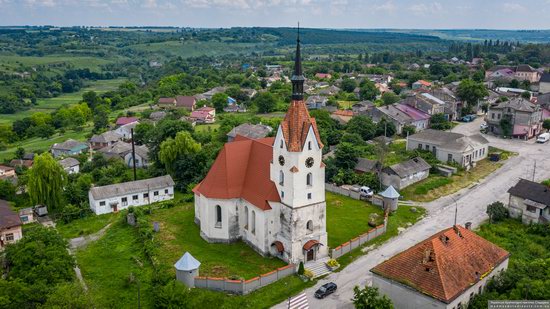
Skala-Podilska is an urban-type settlement with a population of about 4,200 people located in the Borshchiv district of Ternopil Oblast, about 106 km southeast of Ternopil.
One of the main architectural attractions of Skala-Podilska is the Catholic Church of the Assumption of the Blessed Virgin Mary – a stone religious building with Gothic features built in 1719. Skala-Podilska on Google Maps. Photos by: Maxim Ritus.
Tags: church · Ternopil oblast
9
The Gizycki Palace in Novoselytsya
No comments · Posted by Sergei Rzhevsky in Architecture, Regions, Travel
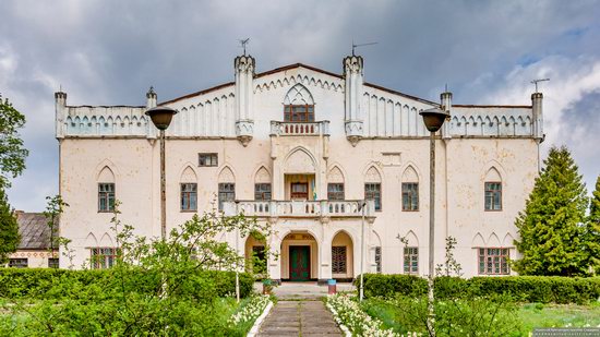
Novoselytsya is a village with a population of about 500 people located in the Starokostiantyniv district of Khmelnytskyi Oblast, about 47 km northeast of Khmelnytskyi. The main attraction of the village is the Gizycki Palace – a monument of architecture of national importance.
This palace in the style of Romanticism with Gothic elements made of specially imported English brick was built by Ludwik Gizycki, who at that time owned the village and surrounding territories, in 1820. Novoselytsya on Google Maps. Photos by: Maxim Ritus.
Tags: Khmelnitsky oblast
2
Picturesque Buildings of the Antoniny Palace
No comments · Posted by Sergei Rzhevsky in Architecture, Regions, Travel
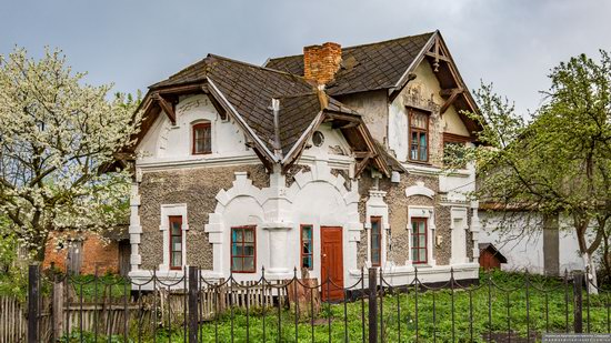
Antoniny is an urban village with a population of about 2,200 people located in the Krasyliv district of the Khmelnytskyi region, about 70 km north of Khmelnytskyi. This settlement under the name of Golodki was first mentioned in documents of the second half of the 14th century. Throughout its history, it belonged to different noble families.
In the 1760s, Barbara Urszula Sanguszko, the owner of the village, transferred Golodki for long-term use to Ignacy Malchevsky, the regent of the Crown Chancellery, who was married to her sister Antonina.
Residential building on Hrafska Street, 24.
Tags: Khmelnitsky oblast
11
New Sarcophagus for the Chernobyl Nuclear Power Plant
No comments · Posted by Sergei Rzhevsky in Ecology, Technology, Travel
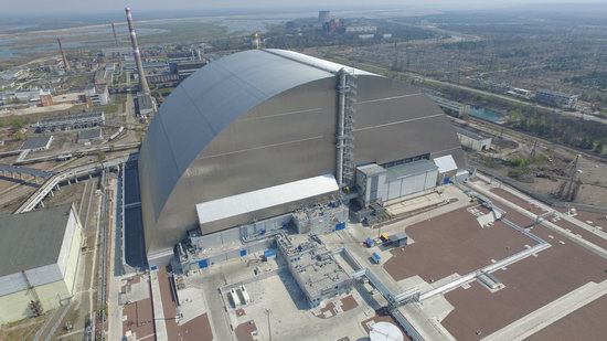
July 10, 2019, 22 years after the organization of the Chernobyl Shelter Fund, the New Safe Confinement (the NSC) was finally put into operation in Pripyat.
The main arch-shaped structure has the following parameters: height – 109 m, length – more than 160 m, span-width – 257 m, weight – more than 31 thousand tons. This is the largest movable land structure in history. Photos by: Anton Usov.
Tags: Kiev oblast · Pripyat city
Svirzh Castle, located in the village of Svirzh in Lviv Oblast, about 44 km south-east of Lviv, is a unique monument of defense architecture of the 15th-17th centuries.
Built as a fortress, after the reconstruction of the 17th century, it lost its original appearance and turned into a picturesque fortified aristocratic residence. Svirzh Castle on Google Maps.
Tags: fortress · Lviv oblast
25
Picturesque Wind Farm in Prymorsk in Southern Ukraine
No comments · Posted by Sergei Rzhevsky in Ecology, Regions, Technology
Prymorsk is a town with a population of about 12 thousand people located in the south of Zaporizhia Oblast, about 42 km west of Berdyansk. This year, a new landmark appeared in the vicinity of the town – huge wind turbines that are visible for dozens of kilometers and even from Berdyansk.
By 2020, it is planned to launch two wind farms – Prymorsk Wind Farm #1 and Prymorsk Wind Farm #2 with a total installed capacity of about 200 megawatts (in total, 52 wind turbines, the blade length – 25 meters). They look especially picturesque when all fields are yellow from harvest. Prymorsk on Google Maps. Photos by: Alexey Novik.
development of renewable energy in Ukraine
Tags: Berdyansk city · Zaporozhye oblast
18
Neo-Gothic Catholic Church in Kamianka-Buzka
No comments · Posted by Sergei Rzhevsky in Architecture, Regions, Travel
Kamianka-Buzka is a small town with a population of about 11 thousand people located in Lviv Oblast, about 41 km north-east of Lviv.
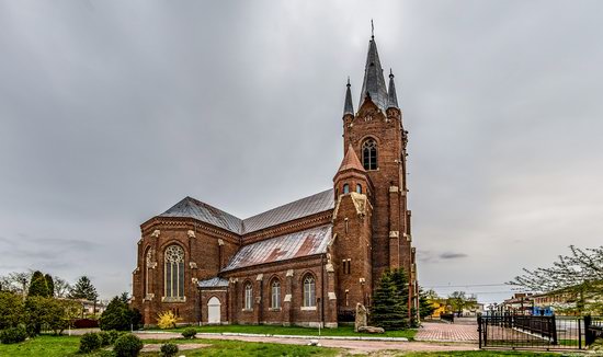
The main architectural dominant of the town is the majestic neo-Gothic Catholic Church of the Assumption of the Blessed Virgin Mary built in the early 20th century, an architectural monument of local importance. Few provincial towns of Ukraine have such a spectacular building. Kamianka-Buzka on Google Maps. Photos by: Maxim Ritus.
Tags: church · Lviv oblast
27
New Pedestrian and Bicycle Bridge in Kyiv
No comments · Posted by Sergei Rzhevsky in Cities, Entertainment, Travel
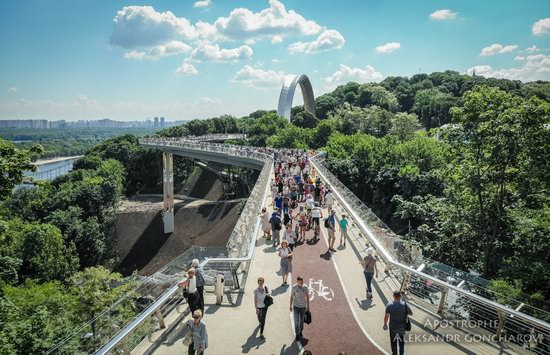
May 25, 2019, in Kyiv, a new pedestrian-bicycle bridge connecting the People’s Friendship Arch and Saint Volodymyr Hill was officially opened.
The bridge offers impressive views of the center of the Ukrainian capital and the Dnieper River. The length of this bridge made of concrete, iron and glass is 212 meters, the width ranges from 6 meters in regular zones to 14 meters in observation zones. Photos by Aleksandr Goncharov for Apostrophe.
Tags: Kiev city
